
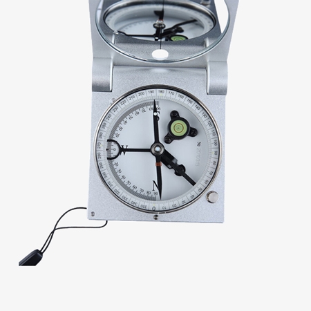
The pocket geological compass is a lightweight, multi-functional tool designed for accurate measurement of geological structures and terrain features. It’s ideal for strike and dip readings, slope angles, and field mapping. Perfect for geologists, and outdoor surveyors who need precision in a compact form.
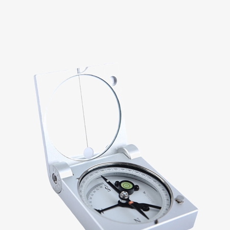
Precision Compass with Damping System and Clinometer Scale
- Constructed with a solid copper housing, the compass offers durability with a classic, corrosion-resistant finish, ideal for long-term field use.
- Ultra-light and compact, this pocket tool is easy to carry, making it perfect for quick measurements during hikes, surveys, or educational fieldwork.
A Durable, Multi-Functional Compass for Outdoor Use
- Pocket geological compass provides accurate strike, dip, and slope angle readings, supporting essential geological structure measurements and basic terrain mapping.
- SISCO geological compass is suitable for a wide range of applications, including geology fieldwork, topographic mapping, outdoor exploration, environmental surveys, and educational training—ideal for both beginners and professionals.
Applications
Geological compasses are used for measuring the orientation of rock layers, faults, and geological structures in field studies, mapping, and resource exploration. They provide accurate strike and dip readings for structural analysis, slope stability assessment, and site evaluation in geology, mining, civil engineering, and environmental applications.

Railway Construction

Mining Industry

Forestry Survey

Mountain Climbing
| Model | SISCO-PGC-DQL2A |
| Material | Copper |
| Damping Time of Needle | 30~60s |
| Dial Scale | 1° |
| Precision of Circle Air Level | 30´± 5´/2mm(20℃) |
| Product Dimensions (L*W*H) | 77.5*66*20(mm) |
| Net Weight | 0.2kg |
Q1: What is the purpose of a geological compass?
A1: A geological compass is used to measure the orientation of rock layers, faults, and other geological features. It helps geologists determine the strike (the horizontal direction of the rock layer) and dip (the angle of the rock layer’s slope) of geological formations, which is essential for geological mapping, analyzing structures, and understanding earth's history.
Q2: How to use a geological compass to measure dip and strike?
A2: To measure the dip, hold the compass level and align it with the rock layer. For strike, adjust the compass to align with the horizontal plane of the rock formation. The readings give you the direction and angle of the formation.
Q3: Can I use a geological compass in extreme weather conditions?
A3: Yes, geological compasses are designed to withstand tough outdoor conditions, including extreme weather. However, it's important to store the compass properly when not in use to avoid damage from moisture, freezing temperatures, or excessive heat. Always ensure the compass is kept in a dry, protective case during severe weather to maintain its accuracy and longevity.
Tips: How to calibrate a geological compass?
- Check the Magnetic Needle: Ensure the needle moves freely and settles accurately. Clean the pivot if necessary.
- Zero the Clinometer: Place the compass on a flat surface—make sure the clinometer reads 0°. Adjust if needed.
- Avoid Magnetic Interference: Stay away from metal objects and electronics during calibration and use.
- Verify with a Reference: Cross-check readings with a known direction or another calibrated compass.
Thank you for buying industrial test and measurement equipment on SISCO.com, all products sold by SISCO and the partner cover a 12 months warranty, effective from the date of receiving the products.
What is covered?
SISCO is responsible for providing free spare parts, and free technical support to assist the customer to repair the defective products until the problem is solved.
What is not covered?
- Product purchased from anyone other than a SISCO store or a SISCO authorized reseller.
- Expendable parts.
- Routine cleaning or normal cosmetic and mechanical wear.
- Damage from misuse, abuse or neglect.
- Damage from use of parts other than SISCO approved.
- Damage from use outside the product’s usage or storage parameters.
- Damage from use of parts not sold by SISCO.
- Damage from modification or incorporation into other products.
- Damage from repair or replacement of warranted parts by a service provider other than a SISCO authorized service provider.
- Damage caused by the application environment not meeting the product usage requirements and the failure to perform preventive maintenance.

Shop on sisco.com for all of your industrial test and measurement equipment & accessories including portable detectors, meters, testers, scales, etc.


